Customers Who Bought This Item Also Bought


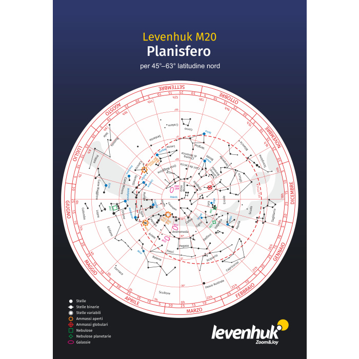
A planisphere is a star map with a rotating calendar that helps to easily and quickly identify which celestial objects can be observed from one’s position at a given date and time. During observations of the night sky, our ancestors noticed constant changes throughout the year. Due to the rotation of our planet (around the Sun and around its own axis), what can be seen in the celestial sphere changes month by month, even during the day! This observation led to the creation of a planisphere that allows people to identify the brightest astronomical objects at a specific future (or past) date and time of observation.
| EAN/UPC | 5905555009162 |
|---|---|
| Manufacturer | LEVENHUK |
| Manufacturer Code | 72553 |
| Price | €7.95 |
A planisphere is a star map with a rotating calendar that helps to easily and quickly identify which celestial objects can be observed from your position on a specific date and time. During observations of the night sky, our ancestors noticed constant changes throughout the year. Due to the rotation of our planet (around the Sun and around its own axis), what can be seen in the celestial sphere changes from month to month, even during the day! This observation led to the creation of a planisphere that allows people to pinpoint the brightest astronomical objects on a specific future (or past) date and time of observation.
How does it work? A planisphere consists of a star map and a disk, with date markings (on the map) and time markings (on the disk). By aligning the date and time, it becomes possible to see the representation of the night sky through the oval window on the disk. It is not possible to select a year on the planisphere because the position of the stars remains the same, both in the past and future.
The Levenhuk M20 planisphere is designed for a northern latitude of 45°–63° (Seattle is at about 47° North, Anchorage about 61° North), therefore it only shows the constellations that can be observed from these coordinates.
Additional information:
The planisphere is very easy to use and the information provided is valuable for observations.
Usage: product for general use. Recommended for children over 3 years.
| Brand | LEVENHUK (USA) |
| Warranty, years | 2 |
| EAN | 5905555009162 |
| Package size (LxWxH), cm | 21x0.5x31 |
| Shipping weight, kg | 0.05 |
| Application | for pupils and students, for adults |
| Edition type | planisphere |
| Data storage medium | printed edition |
| Format, cm | 21x31 |
| Sheets | 1 |
| Treatment | laminated |
| Material | cardboard |
| Map type | constellation map |
| Language | Italian |
| Extra elements | for latitudes between 45° and 63° in the northern hemisphere |
Questo sito utilizza cookie per migliorare la tua esperienza. Cliccando su «Rifiuta», acconsenti all'uso esclusivo dei cookie Necessari. Puoi anche accettare solo i cookie selezionati.


Login and Registration Form